Science, research
Geopark – science, research
Ongoing projects
Danube GeoTour Plus
Danube GeoTour Plus – Project Description
Danube GeoTour Plus builds on established collaboration of 9 geopark partners of diverse institutional background, 2 research and education partners and 18 ASPs. Results of the previous project indicate new trends that embrace the geoparks’ future and still untapped heritage potential.
Depopulation of rural areas, marginalisation of certain resident groups, signs of increased tourism demand on hidden heritage gems, and on the other side, competence, management, product and visitor infrastructure gaps raise the key CHALLENGES in front of the Danube geoparks. Their rural territories encompass 416 municipalities in 9 countries over a surface of 14,601 km2. During the last decade, geoparks have lost 6% of the population and increased visits by 77%, from 317 000 to 562 000.
The project thus AIMS to capitalise and further exploit the recently developed common Danube GeoTour tourism product, its vast heritage potential and existing geopark territorial development model so as to enhance the sustainable tourism opportunities of remote rural communities and to become more inclusive and appreciated by residents and visitors, making their products more valuable and natural and cultural assets managed in a more balanced and sustainable manner. To achieve this, the UNESCO geopark territorial development APPROACH will be upgraded with inclusive, innovative and tailor-made solutions in product value design and visitor management, jointly tested and applied in participating geoparks.
This shall result in the following:
• ENGAGEMENT of vulnerable groups into geopark structures, products and services further to a common engagement strategy and 9 action plans, motivated by new opportunities offered by geoparks and cross-border peer exchanges;
• VALUE GENERATION for local SMEs and raising employment opportunities for vulnerable groups by piloting 9 GeoExperiences as a new participative product development model and functional part of a top-end segment of the Danube GeoTour product and its future cooperation platform;
• BALANCED VISITOR MANAGEMENT based on developed and verified common visitor monitoring solutions for routes, hot spots and larger territories, joint analytical tools and initial visitor redistribution measures. Intense transnational cooperation in these, for Danube geoparks and similar territories important change processes, will significantly improve competences of all 29 participating organisations coming from 8 member and 3 non-member states, in the field of inclusive integrated territorial development, product (experience) innovation management and smart visitor monitoring.
Danube GeoTour Plus is thus not just another transnational tourism product but it is a path into a collaborative platform that will, after the project closure, assure future sustainability of the Danube GeoTour product and enable permanent networking of the Danube geoparks for common, more sustainable and inclusive territorial goals.
Total budget: 2.288.015,00 EUR

Basic geological mapping of the Czech Republic 1: 25 000
Basic geological mapping of the Iron Mountains National Geopark 2014-2018
In cooperation with the Czech Geological Survey basic geological maps of the following map leaves have incurred in the period 2014-2018 – Chvaletice 13-411, 13-412 Přelouč, 13-414 Ronov nad Doubravou, Chrudim 13-423, 13-432 Vilemov and 13-441 Nasavrky. At the same time will be made up special maps showing the situation of geo- and exodynamics, hydrogeological, and geological environment and occurrence of mineral deposits.
The objective of the geological work is to evaluate the geological structure of the west part of the Iron Mountains National Geopark on the basis of new geological mapping in scale. 1: 25 000. In this territory regional geological units are represented: moldanubikum, Kutna Hora Crystalline, ohebské Crystalline, železnohorské crystalline, Železnohorský plutonic complex, the younger Paleozoic of furrows (jihlavská brázda – so called Kraskov perm), Czech Cretaceous Basin (Chrudimská křída and Křída Dlouhé meze), Cenozoic sediments (quaternary accumulation).
Part of the geological work is to evaluate the territory by geophysical, geochemical, hydrogeological, geological aspects and also in terms of deposits and geo-factors of the environment. Geologically significant sites with regard to the needs of the National Geopark Iron Mountain will be also identified and described.
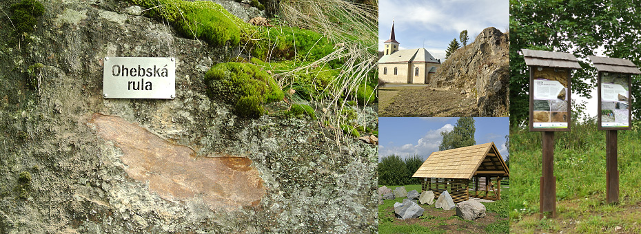
Železné hory – a geologically significant region
Nově spuštěný projekt Železné hory – geologicky významná oblast dává možnost komplexního seznámení návštěvníků tohoto regionu s ohledem na relativně malé území Železných hor. Bohatost a pestrost přírodních jevů je jedinečná a mimořádně zajímavá. Naučné tabule vznikly v rámci projektu „Železné hory- geologicky významná oblast“ spolufinancovaného z prostředků Státního fondu životního prostředí ČR a AOPK ČR. Projekt je strukturován tak, aby bylo možné v pět informačních bezobslužných stanovištích s tématickou náplní PROTEROZOIKUM, PALEOZOIKUM, HLUBINNÉ VYVŘELINY, MEZOZOIKUM A HYDROGEOLOGIE získat obecné informace o daném tématu s odkazy na konkrétní blízké lokality, na kterých budou umístěny informační panely. Tyto panely budou osazeny na 34 lokalitách. Některé z vybraných lokalit jsou ojedinělé v rámci České republiky. Na informačních panelech bude konkrétní jev na té které lokalitě blíže rozveden. U celkem pěti informačních bezobslužných stanovišť bude v plenéru umístěna venkovní expozice tvořená reprezentativními ukázkami horninových bloků s příslušným návěštím – informací. Součástí projektu je rekonstrukce naučné stezky Údolí Doubravy, při které budou vybudovány analogické informační prvky. V rámci venkovní expozice horninových bloků bude u každého z nich umístěna příslušná informace ve formě návěští se stručným komentářem o petrologické, geologické a eventuálně technologické či hydrogeologické charakteristice. Tam, kde to bude technologicky možné, bude na horninovém bloku provedeno vyleštění plochy; důvodem je „vizualizace“ minerální stavby, struktury a textury té které horninové ukázky.
V rámci projektu budou vypracovány metodiky, studie, propagační a informační materiály, které budou směřovat ke zvýšení informovanosti návštěvníků tohoto regionu. Součástí tohoto projektu budou i odborné semináře a exkurze, se kterými Vodní zdroje Chrudim, spol. s r. o., a CHKO Železné hory mají dlouholeté zkušenosti. Doprovodem těchto seminářů bude i publikační činnost, výsledky těchto prací budou prezentovány v odborných a populárně naučných časopisech. Ve spolupráci s CHKO Železné hory a s vysokými školami je možné zadat výzvu diplomantům o zpracování bakalářských či magisterských prací z oboru geologie, petrologie či sociologie.
Kameny a voda
Projekt Kameny a voda je zaměřen na rozvoj kompetencí žáků ve vzdělávání pro udržitelný rozvoj a zlepšování podmínek pro výuku technických, přírodovědných borů a řemesel. Projekt reaguje na potřebu osvojení si teoreticky získaných informací v praxi a na schopnost tyto informace předávat dál. Zvýrazňována je především zpětná vazba na využití praktických poznatků i v ostatních vzdělávacích oborech. Cílovou skupinou jsou žáci a studenti, kteří podstoupí výuku v rámci povinné školní docházky.
Vzdělávání žáků a studentů v geovědách, kde dochází k cílenému propojení teoretických a praktických znalostí s možností improvizace na konkrétní témata v konkrétním regionu je základem pro úspěšné uplatnění v další struktuře vzdělávání. Rozšiřují se tak možnosti uplatnění se nejen na školách gymnaziálního směru, ale i na školách směru technického (např. obory stavební, vodohospodářské, sanační apod.).
Výstupem projektu bude ucelená hodnotící a výuková struktura použitelná pro další školy v regionu, dále exkurzní průvodci, tematická geologická expozice na ZŠ Maleč a venkovní učebny.
Projekt je financován z Operačního programu Vzdělávání pro konkurenceschopnost.